R Meyer with a shepherd,
A pass at the foot of the SE ridge of the
favoured
in summer as a route between the Oberaarioch and
mascent.
It is possible to climb the Finsteraarrothorn by its NW ridge
from the col. PD,
bits of II, 1hr
F From the
glacier to the foot
of a coombe below and SW of the col. Climb up
loose slopes to the
foot of a steep couloir, about 150mhigh, which
leads to the col.
Climb the couloir direct or the rock rib to the S of
it. 1.5 hr
F From the Oberaarjoch hut traverse the Studer glacier and climb
easy snow slopes to
the col. 1hr
Possibly: R Meyer with A
Volker, J Bortis, and A Abblibl,
16 Aug 1812
although they may only have reached a fore-summit.
Most likely: J Leuthold
and J Wahren,
The highest point in the Bernese Oberland. A remote
and
magnificent peak
from any angle, easily picked out in distant views
from other parts of
the
flank and a fine,
long SE ridge. The ordinary route is popular in
both spring (ski
touring parties) and summer.
AD V Fynn
and W Murphy,
54 The
ridge can be climbed from its foot but it is more usual to start it at the
point where it is
crossed by Route 73.
From the
ridge at 3616m. Now
follow the ridge to the foot of the last 100m
high step which is
climbed direct. 5 hr

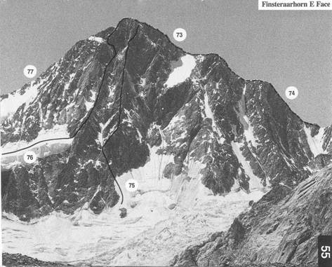
73 SOUTH-WEST
FLANK AND NORTH-WEST RIDGE
PD J Leuthold
and J Withren,
54 U
Almer,
The ordinary route, rather
exposed above the Hugisauel. See also
photo 55
From the
just above Pt 3231.3
m. Climb the glacier N wards (crevasses)
towards the middle
part of the SW ridge. Get onto this at a rocky
projection into the
glacier and so reach the col at Pt 3616 m via
rubble slopes.
Traverse more or less horizontally from the col onto
the slopes beyond,
which are climbed to the Hugisattel.
The route now follows the NW ridge to the
summit but at the
start it is normal
to keep on the SW flank over mixed rock and snow
(II).
Once on the ridge avoid obstacles on their W side. 4-5hr, 2hr in
descent
PD/D G Foster with H Baumann and
P Bernet,
55 The
NW ridge can be climbed in its entirety from the Agassizjoch.
It is
quite difficult when
verglassed. See also photo 54
From the Agassizioch
climb the first rock step on the crest or on the
SW side with no particular
difficulty. The next step is generally
snow and leads to
the Hugisattel where Route 73 is joined. 3-4 hr to
the summit
ED1 A and F Rubi
with Miss M O'Brien,
55 U
Gantenbein, A and
The whole ofthe E
flank of the mountain is interspersed with ribs and
couloirs. This climb
cakes the most northerly and longest of the ribs,
starting from the Finsteraar glacier. It is 1000m high, becoming steeper
towards the top
where it merges into the face, and is mostly rock with two
important sections,
the Red and the
route choice on much
of the climb and the
the L (G Hasler and F Ammatter, 16July
1904). It should only be
attempted after a
long spell of fine weather. Some of the rock is loose and
stone fall is always
a problem. The final slopes are often icy and difficult.
Mostly III with several pitches of lV and V.
From the
the first rocks on
the R and get onto the rib. Climb good rock to the
L side of a triangular
wall. From the top of this the rib becomes
much more distinct. Climb
it by a series of steps and gendarmes (the
lowest of which is
called the
eases.
At 3950m reach the
progress. Avoid it on the R by a broken ramp followed by a slightly
overhanging diddre leading back to the crest at a pronounced gap.
Climb the next, 20 m high, smooth step on its
L flank then a dibdre,
at first slightly
overhanging then vertical, to easier ground. Keep on
the rib over blocks
and short steps to another narrow and smooth
rib. Traverse
horizontally 40 m to the R (delicate) to a couloir
which
is followed on good
rock to an overhang. Climb a secondary rib on
the R to where it
becomes impassable and get into the couloir on its
L. Climb the system of couloirs and grooves
to the ridge 60 m from
the summit. 10-12hr
from the foot of the rib
From the start of the 40m
traverse the rib has been climbed
direct at V+ and
VI-(K Glazek and K Zdzitwieckt,
19 Aug 1967)
72-73