70-71
H George with C Almer,
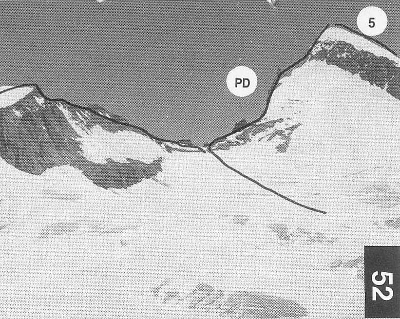
A high pass between the Obers Ischmeer and
the Finsteraar glacier.
It offers an alternative route between
Grindelwald and the Grimsel
Pass to the crossing of the
Agassizjoch, a means of connecting the
Schreckhorn and
Lauteraarsattel.
PD From the Schreckhorn hut
follow Route 49 to the site of the old
Strahlegg hut. From the rocks to the SSE
ofhere get onto snow
slopes leading towards Pt 2922m and follow
them passing just below
this point. According to conditions pass
below or above the next
rock island and then, by steep slopes, reach
more level ground to
the W of Pt 3454m(Alte Strahlegg). Turn S and
cross the glacier
below Pt 3468.7m to the pass. 3 .5 hr
PD/D The difficulty on this side
depends on the state ofthe crevasses.
From the
foot of the NE ridge of the Studerhorn. Climb
up under its N face,
avoiding the first s6rac zone to the S,
before turning NW and
reaching the upper glacier to the L of the
second serac zone. Pass
below the Agassizjoch and reach the pass with
no further difficulty.
3-4hr
R Lindt and G Studer with J and K Blatter and P Sulzer,
5 Aug 1864
An unremarkable mountain from the S but
possessing an attractive
N face which is frequently climbed. From the
summit there are fine
views of the
F A pleasant and
undemanding outing from the Oberaarioch hut. See also
From the hut descend to the col and walk down
the Studer glacier
until level with the foot of the rocks on the
R. Turn N and climb
easily up to the col between the Oberaarhorn
and Altmann.
Traverse the E ridge of the latter to the
summit, avoiding the first
step on the S flank. Easy snow slopes lead to a col. Continue, still on
snow, to a second col (Unders Studerjoch)
before climbing to the
summit of the Studerhorn up easy snow slopes
with the odd steeper
step. 3hr
From the summit walk down
the NW ridge and descend onto
the Studer glacier a little way before
reaching the Obers Studerjoch.
Descend the easy angled glacier to join Route
71 and return to the
hut. 2hr, about 5hr in all
PD+ C and M Blum,
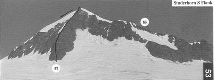
53 A
short climb direct to the summit from the Studer glacier. More sporting
than the traverse.
From the Oberaarjoch hut follow the Studer
glacier to the foot of
the ridge. Start at a little snowy bay just
on the R then keep to the
ridge (III) which is a bit loose in places.
3hr
68 NORTH FACE
TD- P Bonnant and Miss L
Boulaz,
51 W
Manz and
The face is 600m high and reaches 58. at its
steepest. Often climbed.
From the
up the face on the R of the lower s6rac band
and work back L
towards the middle of the face. The exact
line of ascent will then
depend on the state of the seracs in the
upper part of the face. It is
usual to pass these on the R and avoid the
summit cornice on the R
also. 5-8hr

PD+ A Moore and H Walker with M
and J Anderegg,
51 Not
often climbed but the easiest way of reaching the Oberaarioch hut
from the
From the
the glacier bay round the E foot of the
ridge. Traverse R onto the
ridge where it levels out above the steep
lower part. Continue on the
ridge to the summit. 4-5hr
70-71