48-49

M Bannholzer and J Jaun,
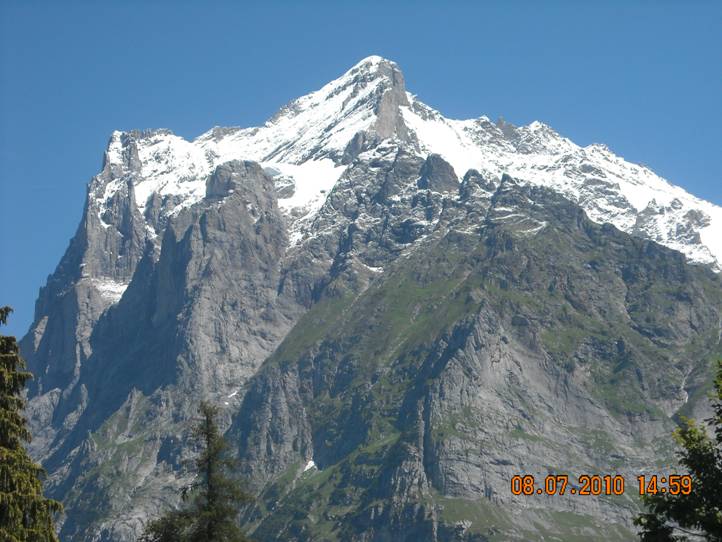
The most important and best known mountain in this section of the
guide-book. Although not quite the highest, it dominates the view
from Grindelwald. Seen from this aspect it appears to be primarily a
rock peak having an extremely steep and impressive NW face. Seen
from the E it is much less daunting and there
is much more snow
cover; it is no suprise
that the mountain was first climbed from this
side. The first confirmed ascent from the Grindelwald side in 1854
is considered to have marked the start of the
'Golden Age' of
alpinism. To climb the mountain is a 'must'
for any alpinist
visiting Grindelwald
for the first time.
AD- A Wills with A Balmat, A Simmond, U Lauener and P Bohren,
45 17 Sept 1854
This is the normal summer route up the
mountain. The route climbs the
Willsgrlitli to the Wettersattel where it joins with the route from the E
)Dossen hut). There is some
danger of rock fall and some quite awkward
slabby rock on the
approach to the Willsgratli, but the ridge itself is
good
rock and provides some very good scrambling.
It is not easy when snow
covered or verglassed
but there is an alternative approach to the
Wettersattel by way ofthe gap called Hick, which links the Chrinnen
glacier to a bay on the N part ofthe Oberer Grindelwald glacier. In good
snow conditions this is quite straightforward
and only PD (in less
favourable
conditions it becomesAD and can be quite dangerous).
See
also photo 45
From the Gleckstein
hut follow a cairned track NNE to the
Chrinnen glacier. GoNE up the glacier, avoiding crevasses on the
L, to a snowy bay (which can be very
crevassed) on the L (NW) of a
rock spur which almost divides the glacier
into two parts. From the
top of the bay get onto this spur (bergschrund to cross) and continue
up the crest, which is gneiss, to where it
gives way to slabby
limestone (2.5 hr). Climb up unpleasantly for
another 200m before
crossing a wide, shallow couloir
on the R to get onto the Willsgrittli.
Keep to the crest of the ridge (II and III-)
to where it peters
out just below the Wettersattel.
Traverse R and climb snow and
rock to the col at
about 3500m (1 .5 -2 hr).
Turn N and follow the snow crest which
narrows towards the
top and merges with the steep upper slopes of
the mountain. Reach
the summit rocks and either climb the steep
snow slope R wards to
the easiest point through the cornice, or
climb rocks further R, or
climb a diddre
trending L to a shoulder just below the summit
45min, 5-6 hr in
all
To climb the alternative route to the Wettersattel reach the
Chrinnen glacier as
above, but then go up the E part of the glacier to
the obvious narrow couloir
in the ridge running S from the
Wettersattel. Climb the couloir (some stone fall danger), which is
about 200m high, and then the steep glacier
bay on the other side of
the ridge. Finally reach a saddle a little to
the E of the Wettersattel
by climbing smooth gneiss slopes (or snow).
Follow the route
described above to the summit (5-6hr).
Descend by either route.
D+
46 The
ridge is about l km long and when viewed from the Chrinnen
glacier
appears as a giant staircase with 5 steep
steps. It provides an excellent
climb, the difficulties being mainly on rock with one steep descent on
snow or ice. At one time there were fixed
ropes on the ridge but
these have long gone. Pitons should be in
place. See also photo47
From the Gleckstein
hut follow Route 34 to the Chrinnen glacier.
On the glacier turn N and head for a rock couloir leading to the crest
of the near horizontal part of the ridge between two high points.
About 20m L ofthe couloir climb good rock, trending first L (some
IV+) then back R on debris-covered but easier
ground, to the crest.
Follow this easily to the col
E of Pt 3053m. This is called Chrinne
and is close to the foot of the ridge. It is
usual from here to make a
short descent on rock and then a steep
snow/ice slope to the Gutz
glacier. Turn R and cross the bergschrund where possible. Get into
a dibdre leading to
the gap between the first and second gendarmes
on the ridge. This can be very trying when verglassed. This point
can be reached from Chrinne
by climbing one pitch R onto the S
face then directly up to the ridge, which is
followed for a short way
before moving L onto the NW flank. This leads
to the gap.
From the gap move round to the R of the ridge
and climb
L wards for a pitch (III and IV) to a belay
in the middle of the tower.
Climb a further 8m, then move R to an exposed
diedre which is
followed to the ridge where it becomes less
steep (40m, IV and V).
Follow the ridge with one short steep step,
to the base of the third
gendarme. Climb this direct (40m, IV). From
its top a steep descent
on snow/ice leads to another gap (the Sichel). Mixed ground now
leads more easily to the summit. Allow 6-9hr
from the hut
48-49