Vorder
and Hinter Galmihorn 3517m and 3486m
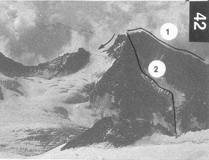
A Barbey, L Kurz with Albrecht and Seiler,
These are two peaks with an attractive
glaciated northern flank.
3 TRAVERSE
F First ascent
party
A pleasant, undemanding outing. It can be taken in either direction.
From the Oberaarjoch hut climb down to the
col and descend the
Studer glacier, at first WSW then S. Pass
below Pt 3060m and cross
the Galmi glacier to the foot of the Vorder Galmihorn. Either climb
the glacier slope direct to the summit or
follow the easy bounding
rock ridge, over the W summit, to the top.
2.5 hr
Descend the snowy N ridge to the Bachilicke
and ascend the
easy SW ridge of the Hinter Galmihorn over
scree, snow and easy
rock. 1hr
Another easy rock ridge leads down to the
Galmilicke from
where straightforward glacier work leads back
to the approach route
((1hr. 5-6hr in
all
Oberaarjoch 3223m
A high pass giving the only easy access to the
higher, central peaks
of the Oberland from the W. Although the pass
itself is high the
starting point is also quite high and so the height gain is not
excessive. It makes a fine start to a traverse of the Oberland from
the E. The W side is a straight forward snow
slope leading onto the
Studer glacier.
F From the Grimsel
Pass drive up a rough track as far as the
Oberaarsee dam, just beyond the Obersar
Berghaus (large car
park). The traffic on this roadway is
controlled by traffic lights.
Ascent can be made, from 8 am onwards, on the
hour and for the
next 10min and the drive should be completed in 20 min (it takes
much less). You can descend on the half hour
similarly. The road is
closed at night from
From the dam cross the dam wall and follow
the track along
the N shore of the Oberaarsee. Keep up R of
the Oberaar glacier
snout and, where the angle eases, walk onto
the glacier and up the
middle of it, usually on bare ice. The angle
eventually steepens and
the glacier becomes snow covered. Continue up
the glacier, more or
less in the middle or just R of it, avoiding
several crevasses, to the
col. 5 hr from the car park
Oberaarhorn 3637m
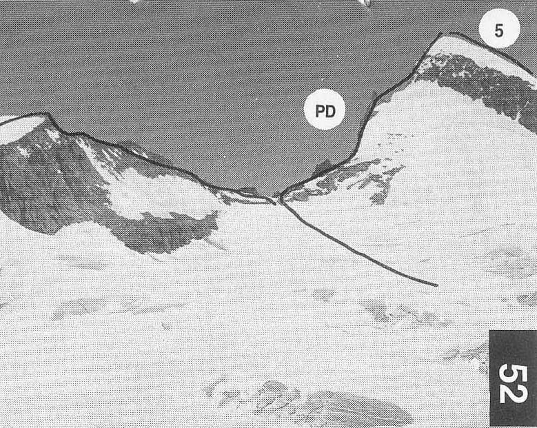
L Stephen and M Anderegg,
A fine rocky pyramid with an easy angled snow
slope on its SW
flank. It is very frequently climbed and has magnificent views all
round from its summit.
F+ First ascent party
52
The route can be combined with (an
ascent/descent of) the W ridge to
make a traverse of the mountain. The W ridge
is PD and is reached at
the col between Altmann and the Oberaarhorn. The rock tower can be
climbed or avoided on the S side.
Behind the Oberaarjoch hut toilet a
way-marked path leads steeply
N wards to the snowfield which forms the
upper part of the route.
Climb this, sometimes icy, to the summit.
1-1.5 hr
32-33