64-65
Lauteraahorn 4042 m.
53 SOUTH-WEST RIDGE, SOUTH FACE AND
SOUTH-EAST
AD+ RIDGE
48 G
Lammer solo,

The most direct route from the Schreckhorn hut, it avoids the difficulties
Of the SW ridge and enjoys the best part of
the S face couloir route. Not
particularly
pleasant.
From the Schreckhorn
hut follow Pt 52 to the foot of the third
section of the SW
ridge. From here traverse across the S face below
the steep summit
wall, at first descending a short couloir and then
crossing ribs and
couloirs as far as an easy but loose couloir which
leads up to the SE
ridge. Follow this as for Route 51 to the summit.
About 7hr
In descent the point at which the S face
traverse is started is
not easy to find if
you have not already climbed this way. It is worth
descending the ridge
to the E of the loose couloir until you can see
the shoulder on the
SW ridge. The traverse across the face is at the
height of the
shoulder. In this way you should avoid a tempting
higher traverse line
which disappears into difficult terrain.
Lauteraahorn 4042 m.
54 NORTH-WEST (LAUTERAAR) RIDGE
D+ H Kuntze with P and R Bernet,
50 G
The climb is described from the Schrecksattel but is probably best
combined with an
ascent of the SW ridge and a descent ofthe SE ridge
of
the Schreckhorn (Routes 57 and 56) to make a magn(ficent, but lengthy
traverse ofthe twin peaks. The ridge itselfis
saw-toothed with many
small gendarmes.
Since both flanks of the ridge are loose it is advisable to
keep the crest over
all the obstacles.
From the Schrecksattel
(3914m) follow the crest as closely as
possible all the
way. The most difficult step is a 4-5m high tower
which lies between
the first and second steeper parts of the ridge.
This is climbed either on the L or the R side (III+). 4-5hr

55 BY THE EAST-NORTH-EAST RIDGE OF POINT 4011m
D+
50 This
is a fine remote climb on good gneiss which is rather delicate if it is
not free from snow.
From Pt4011m the summit is easily reached.
From the Lauteraar
hut climb the Lauteraar glacier by Route 47 to
the level of the
foot of the ridge. Get onto Pt 2995.2m by rock or
snow from the L. Now
continue easily on snow to about 3450m. Get
onto the rock ridge
ahead from the L and follow it, making short
deviations to the L
to the top of a rock triangle. Keep to the crest
from here to Pt
4011m. Keep to the crest of the NW ridge to reach
the summit of the
mountain. 10-12hr
Schreckhorn 4078m
L Stephen, C and P Michel and U Almer,
A splendid mountain whose summit is much
sought after. Unlike
most of the Lauteraarhorn, its close neighbour,
the rock is of
excellent quality. It
also supports a very fine snow/ice route on its N
face.
Shreckhorn 4078m
56 VIA THE
SCHRECKSATTEL AND EAST-SOUTH-EAST
AD+ RIDGE
49 E
Von Fellenberg with P Michel, P Infibnit
and P Egger,
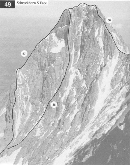
This was at one time the normal route but it
is rarely climbed these days,
partly on account of
lack of snow in the couloirs below the sattel, partly
because of the
difficulty in crossing the bergschrund and also the
difficulty of
climbing the Elliottswengli on the SE ridge. Below the
sattel
the route is exposed
to stone fall and snow-slides (especially in descent). It
is described here as
a means (when conditions allow) of reaching the
Schrecksattel in order to climb the NW ridge of the Lauteraarhorn.
The
ESE ridge is described in descent for the
combined Schreckhorn-
Lauteraarhorn
traverse. See also photos48 and 50
From the Schreckhorn
hut follow Pt 57 to the foot of the couloir
leading to the Schrecksattel (3.5 -4hr). Cross the bergschrund
and
climb the snow slope
into the couloir. Climb R wards on a rock
buttress, which is
easy, as far as the bend in the couloir. Now follow
the couloir back L to the sattel. 1 .5 -2hr
To descend from the Schreckhorn
summit by the ESE ridge
follow the ridge to a
fore-summit to the SE then follow the ridge
creston
good rock to a small gap at the start of a steeper section that
has a number of
small gendarmes along it. These are passed on the
L (N) side on steep snow or ice (Elliottswengli- named after
J Elliott who fell from here in July 1869).
There are several pitons
in place. The ridge
then leads easily down to the Schrecksattel.
1.5 -2hr
64-65