142-143
Miss Brevoort and W Little with M Salzmann and two others,
A fairly popular summit but little more than a training peak. There
is some good rock on the ridges but the flanks are rotten.
209 WEST-SOUTH-WEST
RIDGE AND SOUTH-WEST FLANK
PD Miss J and C Hopkinson, 1894
This is the ordinary route and avoids the more difficult part of the
WSW ridge.
From the Oberaletsch hut follow a vague path NE to get onto the
ridge oriented W at this point. Just beyond Pt 2953.1m keep on the
N side past a gap and several gendarmes but otherwise keep to the
crest to a height of about 3230m. Make a descent on the E side for a
few m then climb snow/boulder slopes below the ridge to the foot
(about 3400m) of a snow filled couloir descending from a gap in the
ridge. On the bounding E side of the couloir is an obvious V notch.
Climb to this then up the ridge above it for a few m before
traversing E onto the upper edge of a snowy bay. Follow this to a
small couloir and climb this a short distance then work up R on
slabby rocks to the WSW ridge. Follow this to the summit. 4-5hr
210 WEST-SOUTH-WEST
RIDGE INTEGRAL
AD+ J Kuhn and H Rothlisberger.
A long climb on good granite and recommended. Pitches of III and IV.
From the Oberaletsch hut follow Route 209 to about 3230m. Now
keep mainly on the crest which has some splendid climbing. At one
point a large slabby block bars the way. Climb this direct (pitons) or
pass it on the R (pitons, a bit easier). Beyond a distinct gap a steep
wall is climbed direct to gain the final summit ridge. 5-6hr
It is possible to leave the ridge at about the mid-point to get
onto the ordinary route.
AD+ G Young with C Ruppen,
What amounts to an alternative finish to the ordinary route. Bits of III.
It climbs only the last part of this long rid ge.
From the foot of the couloir at about 3400m on the ordinary route
(209) traverse E to a snow filled couloir. Climb this to a gap between
the last tower on the ridge and the main summit. From the gap
climb the S face before slanting R to the ridge which is followed to
the summit. 5-6hr
W Coolidge and A Walden,
The highest point hereabouts which, although not often climbed,
provides a good training route.
AD From the N: L Kurz and H Rieckel with F Graf inr and C Lauener,
From the Oberaletsch hut walk up the Oberaletsch glacier as far as
the unnamed glacier on the W flank of the mountain. Go up this,
keeping on the R side of the rocks below Pt 3368m. Pass above this
point and reach the crest of the ridge running NW from Pt 3675m.
Climb the ridge over this point (good rock) and continue to the next
top (Pt 3723.9m, Sattelhorn) turning gendarmes on the W side.
Cross a snowy saddle to the Geisshorn. 6-7hr
Descend the SW ridge and continue along the ridge to the
summit of the Rotstock. Return to the Oberaletsch glacier by the W
ridge of this peak (snow and rock). 3V2hr, 10-12hr in all
F Tuckett with J Bennen, P Bohren and V
Tairraz,
The second highest summit in the Bernese Oberland and much
sought after. It is a big mountain and much higher than anything
close by. There are three principal ridges which separate the three
glacier systems that converge on the mountain and bear its name.
Most of the climbing is not too demanding but is always interesting.
Any two of the ridges can be used to create a traverse of the peak
and it is particularly rewarding to combine a traverse with an ascent
of the Sattelhorn, from the N, or an ascent of the Dreieckhorn from
Konkordia. The mountain has a magnificent glaciated N face.
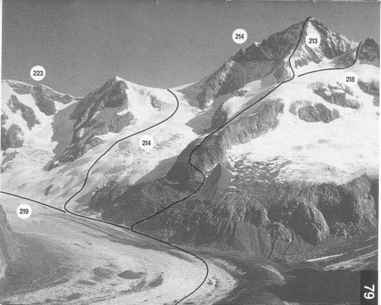
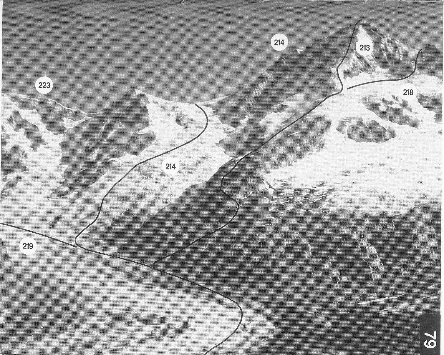
PD+ L Liechti and T Middlemore with A Kummer and a porter,
79
The ordinary route from the Oberaletsch hut, the most convenient hut for
access to the mountain. It is fairly steep with adequately sound rock but it
can be time consuming if the usual snow section becomes icy. In descent
the top of the rib is not easy to locate in mist.
From the Oberaletsch hut walk NE up the Oberaletsch glacier to
below Pt 2860m. It may be possible to get onto the rock barrier near
here and make a rising traverse L (shortest way), if not continue on
the glacier until SW of Pt 3100.9m. From here a track leads back R
on the lowest rock shelf. By either way reach a hollow between the
rocks and moraine S of Pt 3100.9m. Climb up this for a few minutes
and then get onto the crest of the rib on the L. Keep on the rib or its
E side over large blocks to Pt 3382m. 3V2hr
Snow slopes (possible bergschrund and crevasses) are now
climbed, curving gradually to the E before finally turning back W to
Pt 3736m. This is the start of the true SW rib which is followed to a
fairly steep snow slope below the summit rocks. Climb this and then
easily up the rocks to the summit. 3-4hr, 7-8hr in all
In descent: from the summit go down SSW to find the top of
the rib.
142-143