122-123
TD+
73 The original route on the face. In present lean snow conditions it is not
being climbed (at least in summer). The lower part is seriously threatened
by sierac fall.
The climb starts at the foot of the central couloir and climbs L wards
towards the prominent rock barrier at half-height. The crux of the
climb is a L to R traverse through the top of this barrier. Above this
obstacle the route keeps trending L to finish on the NE ridge some
distance from the summit.
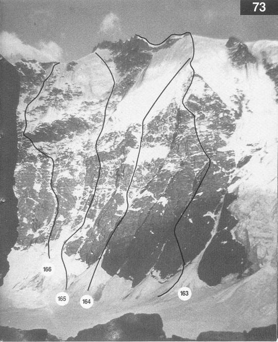
EDI L
This climb is a more direct and harder variation of the Welzenbach
Route and was considered to be much safer. The start is a couloir below
and slightly L of the crux pitch on the original route. After a few hundred
meters some quite difficult climbing (Scottish winter IV) is encountered
moving R to the ice field below the rock barrier. After crossing the barrier
a more direct line is taken (easier climbing now but sustained) to exit
on the NE ridge. 8-9hr
TD J Barry and D Nicholls, Aug 1977
The start is as for the Griffin-BartleuRoute but in this case the couloir is
climbed in its entirety. It crosses mixed ground with two or three superb
ice pitches (700-800). Some of the difficulties can be avoided and the
route finishes well down the NE ridge. 12hr
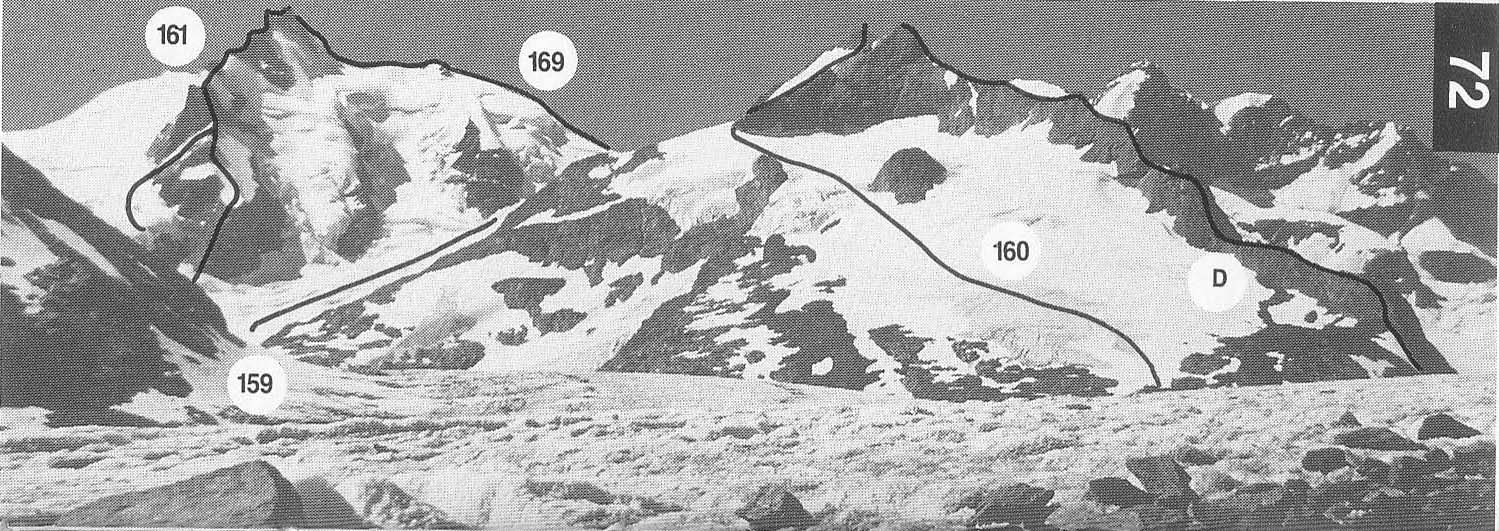
169 NORTH-EAST
RIDGE (Gletcherhorn 3983 m)
AD Mme and M Gallet with J Kalbermatten and C Kaufmann,
72
Not greatly popular but could be combined with the W ridge to make a
traverse of the mountain.
From the Konkordia or Hollandia huts follow Route 159 to the
Louwitor. Make a short descent to a col at Pt 3644m. Follow the
crest of the ridge, which is corniced in its central part, to the rocks
of the upper part. Climb these direct to the summit (III) or traverse
to the S and reach the upper part of the SE ridge to gain the summit.
2hr from the Louwitor
T Brown with P Bohren and P Schlegel,
On earlier editions of the map it was named Ebnefluh. Its main
attraction is its N flank which provides some good and not too
serious ice routes. On the S side there are fairly gently inclined snow
slopes which provide some interest to ski-mountaineers in spring
time, although the ascent is often spoiled by planes and helicopters
landing close to the Abeni Flue-joch.
F First ascent party
An easy outing in fine glacier terrain.
From the Hollandia hut climb the Abeni Fluefirn. The first part is
crevassed, but as the angle eases it is much less so. Follow the
obvious curving line to reach the col NW of Pt 3928m. The snowy
ridge leads to the summit. 2-3hr
It is also quite common to reach the summit by climbing to
the colE of Pt 3811.4m and following the W ridge to the top.
171 NORTH-WEST
(ROTI FLUE) RIDGE
TD O Hug and H Lauper,
74 This is a good mixed climb, the rock difficulties being no more than III
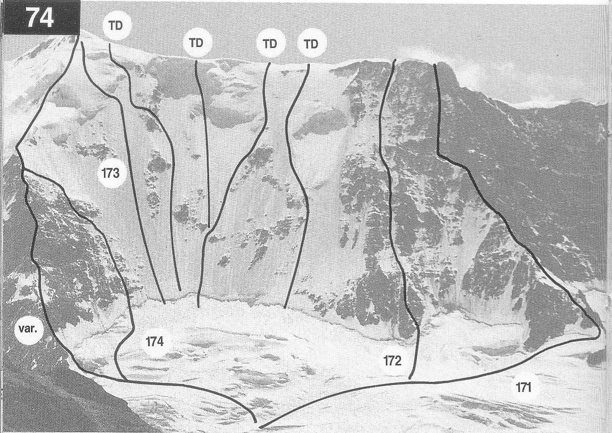
in dry conditions but much harder when verglassed. The lower part of the
rid ge is the hardest.
From the Rottal hut reach the foot of the ridge at a snowy bay which
is climbed to attain the ridge at about 2950m. Climb the crest over a
series of ever steepening steps. Avoid a rocky projection on the L
(N) side and get back to the crest at a small gap not much below
Pt 3811.4m. Traverse into a steep couloir and climb this to reach
the corniced ridge just E of the distictive gendarme of Pt 3811.4m.
Continue along the ridge to the summit. 8hr
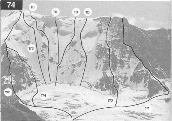
172 NORTH FACE TO
TD P Gabarrou and P Steiner,
74 Probably the hardest route on the N face, this climbs to the ridge just E of
Pt3811.4m by a fairly direct line. It is mainly ice with two steep sections
of 80-85 degree
D+ C Macdonald with P Bernet and
C Jossi snt,
74 Friedli, 1964
In good snow/ice conditions (usually in early summer) it is possible to
climb almost anywhere on the face at about the same grade. The face is
about 900m high and almost as wide, with an angle of500-556. Choice
of route will often depend on where it is possible to cross the bergschrund.
Some lines finish on the ridge between Pt 3811.4m and the summit,
whilst others finish at the summit. A line up the centre of the face ending
on the ridge about mid-way between the summit and Pt 3811.4m is about
the easiest, and is sometimes used as a means of descent on this side of the
Lauterbrunnen Wall.
From the Rottalhut cross the glacier to the foot of the face and
climb the bergscrund wherever possible. Climb as direct as you
wish to the ridge or summit. 5-8hr
122-123